
How to analyze PPGIS data collected in 3D?
Kamyar Hasanzadeh & Nora Fagerholm, Department of Geography and Geology, University of Turku
Although we experience the space around us three-dimensionally, altitude, as the third dimension, has been often absent from PPGIS research and practice. This is largely because of the complexity of implementing surveys in 3D but can also be attributed to a lack of analytical preparedness for using such data.
Our study complements 3D PPGIS data collected from a pilot study of the Aninkainen block in Turku, Finland with synthetic, i.e. artificially manufactured, data to propose an analytical framework for the study of 3D PPGIS data. The analytical framework divides methods based on the geographical scale into two groups: micro- and macro-scale analysis. In this framework, we propose the use of geospatial metrics to analyze 3D PPGIS data.
We argue that while this multidisciplinary area of research is in its infancy, use of intuitive 3D adapted geometric and landscape metrics can help overcome some of complexities associated with use of this emerging participatory data. In the article we also discuss the limitations and envisioning areas for future research.
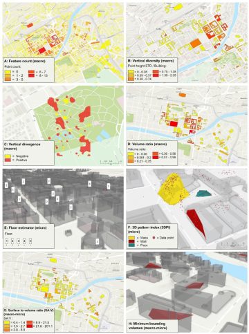
Figure. Exemplary outputs from some of the macro and micro scale metrics calculated with 3D PPGIS data.
Hasanzadeh, K., Fagerholm, N., Skov-Petersen, H., Stahl Olafsson, A. (2023). A methodological framework for analyzing PPGIS data collected in 3D. International Journal of Digital Earth, 16, 3435-3455. https://doi.org/10.1080/17538947.2023.2250739