How to generate synthetic PPGIS data – and why?
Nora Fagerholm & Kamyar Hasanzadeh, Department of Geography and Geology, University of Turku
PPGIS is often implemented through online surveys and points are the most common mapped features. PPGIS data provide invaluable experiential spatial knowledge. Nevertheless, collection of this data for purely methodological purposes may be costly and unnecessary.
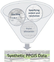
To overcome this challenge, we developed a context-aware method that can learn from previously collected PPGIS data and create a realistic dataset that can be used for methodological development purposes. With our method, synthetic PPGIS data can be generated for any desired geographical extent in both 2D and 3D, i.e. with Z coordinates.
The latter is particularly important as 3D PPGIS is an emerging frontier and limited infrastructures currently exist for collection of such data. Hence, while the relevant technology is developing, spatial analytical developments can also advance using such synthetic data.
Hasanzadeh, K. & Fagerholm, N. (2022). A learning-based algorithm for generation of synthetic participatory mapping data in 2D and 3D. Methods X, 9, 101871. https://doi.org/10.1016/j.mex.2022.101871