
Using integrated approaches for temporal landscape characterisation to assess the future sustainability of a rural landscape in Northwest Spain
Kyle P. Hearn, Faculty of Social Sciences and Humanities, University of Deusto, Bilbao, Spain
Kyle P. Hearn from the University of Deusto in Spain and frequent collaborator with Nora Fagerholm of the Sustainable Landscape Systems Research Group have published a scientific article demonstrating the value of using trans- and interdisciplinary approaches to temporal landscape characterisation of a rural landscape in the Meseta Iberica Biosphere Reserve located in the northwest of the Iberian Peninsula.
Historically sustainable agrosilvopastoral landscapes throughout Europe are in danger of disappearing and with them the knowledge of maintaining these historical, sustainable forms of territorial management. Research design that combines Local Spatial Knowledge (LSK) with scientific methods are effective approaches to better understand a landscape’s temporal land use and land cover (LULC), its traditional management and its heritage.
Our research utilised a trans- and interdisciplinary approach combining ‘bottom-up’ participatory mapping and ethnographic interviews with the ‘top-down’ Historic Landscape Characterisation (HLC) methodology. We characterised and analysed past to present LULC changes and assessed the future sustainability of a rural landscape case study in NW Spain. HLC uses historical and contemporary empirical spatial data to temporally characterise a landscape according to attributes that typify the LULC of a region or locale.

Figure 1. Participatory Mapping with informant in Pino del Oro, Spain August 2018. Photo: Kyle P. Hearn.
We developed HLC maps that reflect LULC between the 1900s and the 2010s in our case study. The ethnographic data from the interviews and participatory mapping were integrated into the HLC temporal maps to characterise and analyse LULC over time. In the participatory mapping, informants disclosed specific land use attributes of the case study village landscape that where unknown by official mapping sources such as the Spanish cadastre. Among these attributes were zones of crop rotation, pasturing, and water milling. Using the HLC maps, a statistical analysis of temporal changes of landscape attributes was completed.
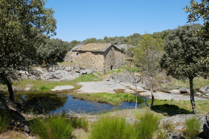
Figure 2. Historic watermill mapped through participatory mapping in Pino del Oro, Spain. Photo: Kyle P. Hearn.

Figure 3. Historic Landscape Characterisation map of Pino del Oro village in Early 20th Century.
Ethnographic interviews conducted from 2017 to 2021 revealed informants’ perceptions of a decline in biodiversity and agrosilvopastoralism as result of landscape abandonment. Landscape abandonment, according to informants, led to more vegetative growth and ultimately caused devasting wildfires. Participatory mapping with informants, created new spatial data of historical land cover and land use traditions representative of traditional landscape management of agrosilvopastoral/multifunctional systems. The HLC maps with their combined ethnographic and participatory data and empirical sources confirmed ethnographic perceptions of a loss of landscape multifunctionality due to depopulation.
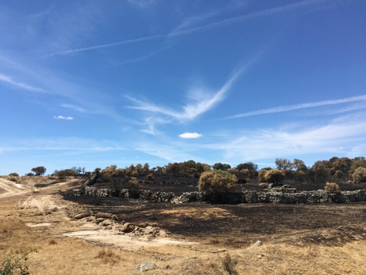
Figure 4. Devastating wildfire of Pino del Oro in 2017. Photo: Kyle P. Hearn.
The integrative approach used in this study highlights a landscape marked by abandonment, increased vegetative growth, nature conservation measures, and wildfires. This research demonstrates the value of inter- and transdisciplinary approaches to analyse and understand temporal landscape change. The study’s spatial data, created in collaboration with local informants, can serve as a possible planning tool for sustainable rural development, adaptation to climate change, and ultimately, heritage conservation.
Read the published open access article: Hearn, Kyle P. and Fagerholm, Nora 2025. The characterisation and future sustainability of a rural landscape: using integrated approaches for temporal heritage landscape analysis in Northwest Spain