Research data
LiDAR DEM data
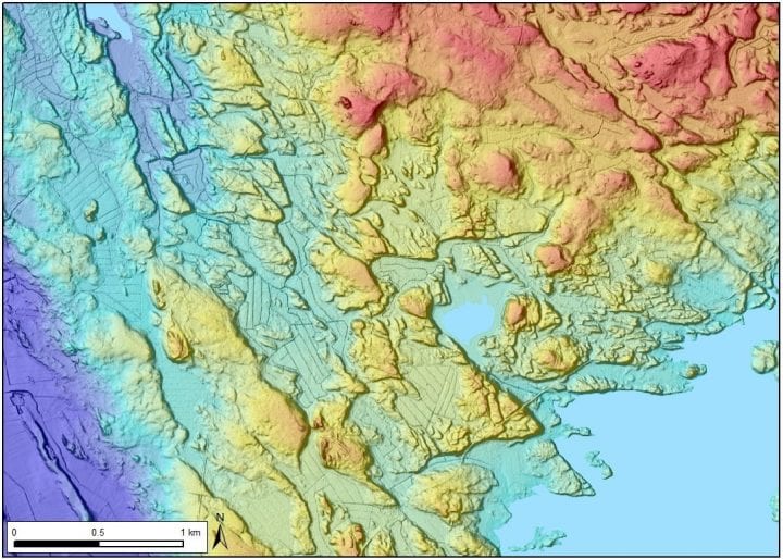 The group uses high-resolution LiDAR DEMs (2-m grid/0.3 m vertical resolution) with the standardized MDOW (multidirectional/hill-shaded) and slope visualization derivatives (NLS and GTK) as a primary geomorphological mapping tool.
The LiDAR-data is supported by other digital datasets, including:
- Aerial photographs (NLS)
- Base maps and lower resolution DEMs (NLS)
- Maps of Quaternary sediments and thickness of superficial deposits
(scales 1:20 000 – 1:100 000) (GTK) - Glacial dynamic information, such as lineations, hummocky moraines and glaciofluvial
deposits (cf. Putkinen et al., 2017) (GTK) - Highest shoreline contours and relative proglacial water depth
(Ojala et al., 2013) (GTK) - Bedrock maps (scales 1:20 000 – 1:100 000) (GTK)
- Aerogeophysical mapping data, such as magnetic anomalies (GTK)
All of the above-mentioned data sets are freely available from the National Land Survey of Finland (NLS): (https://www.maanmittauslaitos.fi/en) and Geological Survey of Finland (GTK) Maankamara map service (http://gtkdata.gtk.fi/maankamara/) as well as from Hakku spatial data products service (https://hakku.gtk.fi/en). Data processing and visualizations are done either by using ArcGIS (ESRI) software or the open-source QGIS software. The mapping data are supported by the results of relevant earlier scientific studies and GTK’s database of test pits.
The description of the laser scanning data of the National Land Survey of Finland (NLS) can be found here:
Geological Survey of Finland’s (GTK) free map web map application Maankamara includes features such as precise elevation data hillshading, superficial deposits and bedrock maps and aerial photographs. The description and access to Maankamara map service can be found here:
http://en.gtk.fi/informationservices/service_descriptions/maankamara.html
Sedimentological data

The LiDAR data is supported by sedimentological data collected from test pits and excavation sites.
Ground penetrating radar profiles
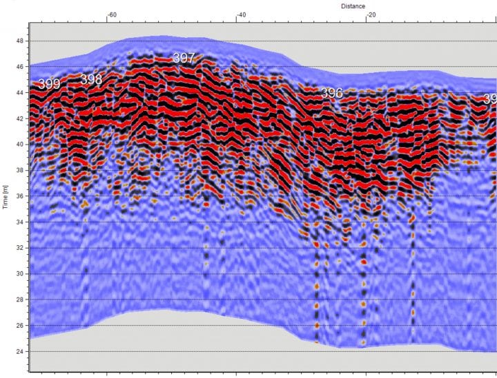 The ground penetrating radar profiles were acquired by Geological Survey of Finland. The profiles were mostly driven along forest roads or paths using a 100 Mhz antennae.