Remote sensing & laser scanning in fluvial studies
We use several close-range remote sensing techniques to study riverine processes.
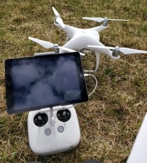 Photogrammetry and UAV applications in fluvial studies
We use aerial photography to create both terrestrial and bathymetric models in high spatial resolution. We apply Structure from Motion-technique as well as optical-empirical bathymetric modelling. Several models have been tested and developed in clear water rivers of Finnish Lapland.
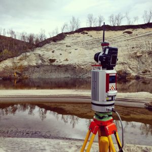
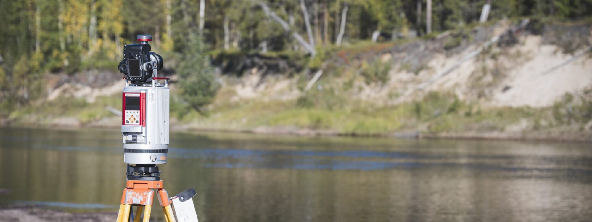
Lidar applications in fluvial research
Laser scanning has enabled highly accurate data gathering with increased horizontal and vertical precision and better availability of detailed spatial data. LiDAR-based approaches are increasingly used in fluvial geomorphology. In our research, we apply airborne laser scanning (ALS), ALS systems for bathymetric measurements, fixed-position terrestrial laser scanning (TLS) and mobile laser scanning (MLS), such asboat- and cart-based mapping systems (BoMMS/CartMMS) to study river dynamics.
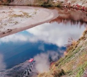
Acoustic profiler in RC platform
ADCP (Acoustic Doppler current profiler) is a remote sensing device to measure flow depth and flow velocities. The measurements derive flow velocity from the Doppler shift of the measured return of an emitted acoustic signal that is reflected off suspended matter in the water column. Installing the device on a remote controlled platform, allows for rapid and dense measurements without disturbing the flow and bed morphology. In addition to standard discharge measurements, we apply ADCP to study 3-dimensional flow fields and morphological changes.
Research examples
Kasvi, E., Salmela, J., Lotsari, E., Kumpula, T. and Lane, S. (2019). Comparison of remote sensing based approaches for mapping bathymetry of shallow, clear water rivers. Geomorphology, 333, pp.180-197. DOI.
Abstract:
Shallow rivers provide important habitat for various aquatic and terrestrial species. The bathymetry of such environments is, however, difficult to measure as devices and approaches have been traditionally developed mainly for deeper waters. This study addresses the mapping of shallow water bathymetry with high spatial resolution and accuracy by comparing three remote sensing (RS) approaches: one based on echo sounding (active RS) and two on photogrammetry (passive RS): bathymetric Structure from Motion (SfM) and optical modelling (Figure 1). The tests were conducted on a 500 m long and ~30 m wide reach of sand-bedded meandering river: (1) during a rising spring flood (Q = 10–15 m3/s) with medium turbidity and high water color and; (2) during autumn low discharge (Q = 4 m3/s) with low turbidity and color. Each method was used to create bathymetric models. The models were compared with high precision field measurements with a mean point spacing of 0.86 m. Echo sounding provided the most accurate (ME~−0.02 m) and precise (SDE = ± 0.08 m) bathymetric models despite the high degree of interpolationneeded. However, the echo sounding-based models were spatially restricted to areas deeper than 0.2 m and no small scale bathymetric variability was captured. The quality of the bathymetric SfM was highly sensitive to flow turbidity and color and therefore depth. However, bathymetric SfM suffers less from substrate variability, turbulent flow or large stones and cobbles on the river bed than optical modelling. Color and depth did affect optical model performance, but clearly less than the bathymetric SfM. The optical model accuracy improved in autumn with lower water color and turbidity (ME = −0.05) compared to spring (ME = −0.12). Correlations between the measured and modelled depth values (r = 0.96) and the models precision (SDE = 0.09–0.11) were close to those achieved with echo sounding. Shadows caused by riparian vegetation restricted the spatial extent of the optical models.
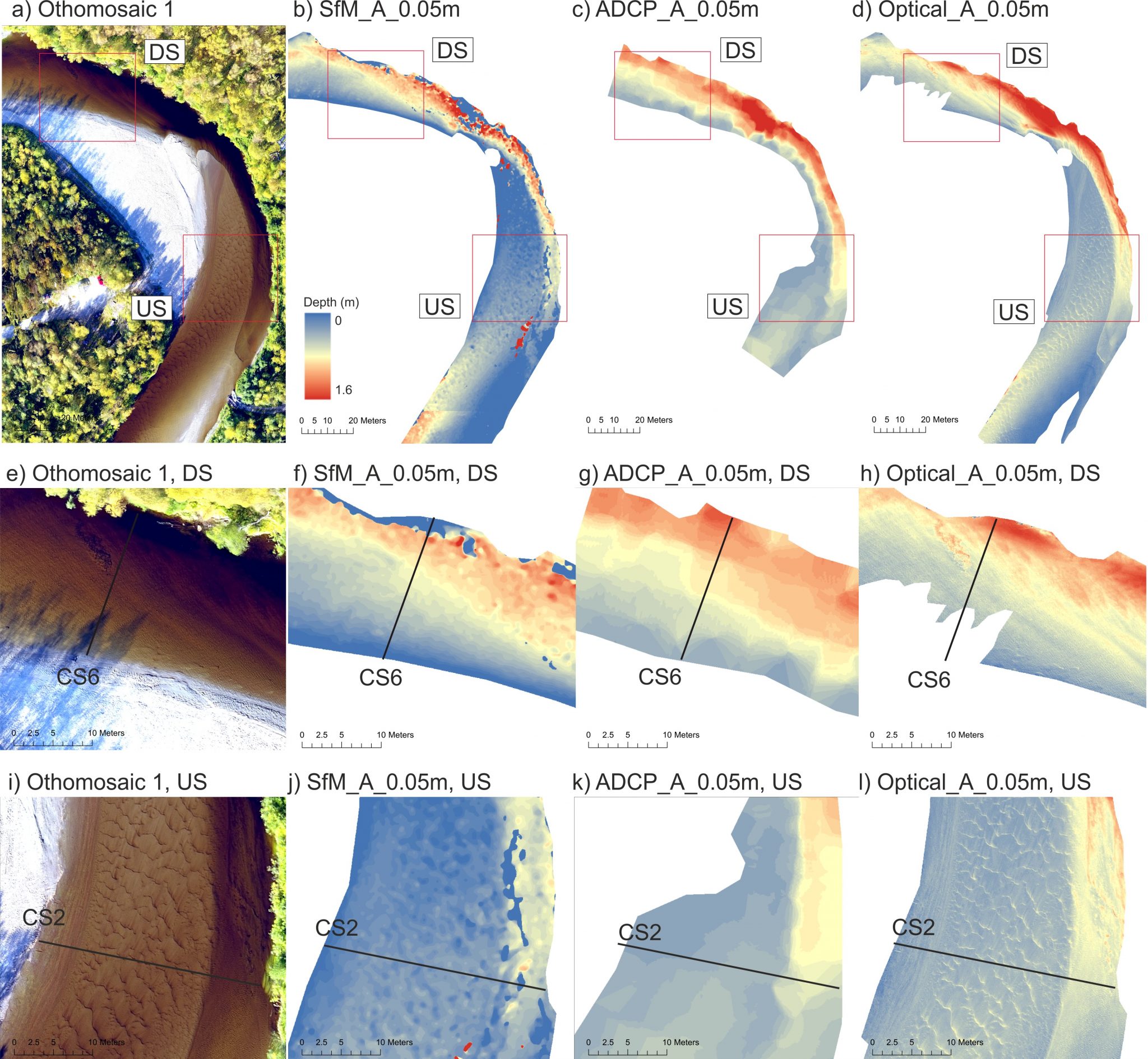
Figure 1.Orthomosaic and three different bathymetric models with 0.05 m resolution: bathymetric Structure-from-Motion (SfM), Acoustic Doppler current profiler, and optical-empirical modelling-based.
(a–d) the entire area of interest. The red rectangles delineate the inspection windows at downstream (DS) and upstream (US) part of the bend.
(e–h) The inspection windows at the downstream part of the bend.
(i–l) The inspection windows at the upstream part of the bend. (From Kasvi et al, 2019, Geomorphology).
Kasvi, E., Hooke, J., Kurkela, M., Vaaja, M., Virtanen, J., Hyyppä, H. and Alho, P. (2017). Modern empirical and modelling study approaches in fluvial geomorphology to elucidate sub-bend-scale meander dynamics. Progress in Physical Geography: Earth and Environment, 41(5), pp. 533-569. DOI.
Abstract:
Major developments in theory and modelling techniques have taken place within the past couple of decades in the field of the fluvial geomorphology. In this review, we examine the state-of-the-art empirical and modelling approaches and discuss their potential benefits and shortcomings in deepening understanding of the sub-bend-scale fluvial geomorphology of meander bends. Meandering rivers represent very complex 3D flow and sedimentary processes. We focus on high-resolution techniques which have improved the spatial and temporal resolution of the data and thereby enabled investigation of processes, which have been thus far beyond the capacity of the measurement techniques. This review covers the measurement techniques applied in the field and in laboratory circumstances as well as the close-range remote sensing techniques and computational approaches. We discuss the key research questions in fluvial geomorphology of meander bends and demonstrate how the contemporary approaches have been and could be applied to solve these questions.
Kasvi, E., Laamanen, L., Lotsari, E. and Alho, P. (2017). Flow Patterns and Morphological Changes in a Sandy Meander Bend during a Flood—Spatially and Temporally Intensive ADCP Measurement Approach. Water, 9(2), p.106. DOI.
Abstract:
The fluvio-geomorphological processes in meander bends are spatially uneven in distribution. Typically, higher velocities and erosion take place near the outer bank beyond the bend apex, while the inner bend point bar grows laterally towards the outer bank, increasing the bend amplitude (Figure 2). These dynamics maintain the meander evolution. Even though this development is found in meandering rivers independent of soil or environmental characteristics, each river still seems to behave unpredictably. The special mechanisms that determine the rate and occasion of morphological changes remain unclear. The aim of this study is to offer new insights regarding flow-induced morphological changes in meander using a novel study approach. We focused on short-term and small-spatial-scale changes by conducting a spatially and temporally (daily) intensive survey during a flood (a period of nine days) with an ADCP attached to a remotely controlled mini-boat. Based on our analysis, the flood duration and the rate of discharge increase and decrease seems to play key roles in determining channel changes by controlling the flow velocities and depth and the backwater effect may have notable influence on the morphological processes. We discuss themes such as the interaction of inner and outer bend processes and the longer-term development of meander bends.
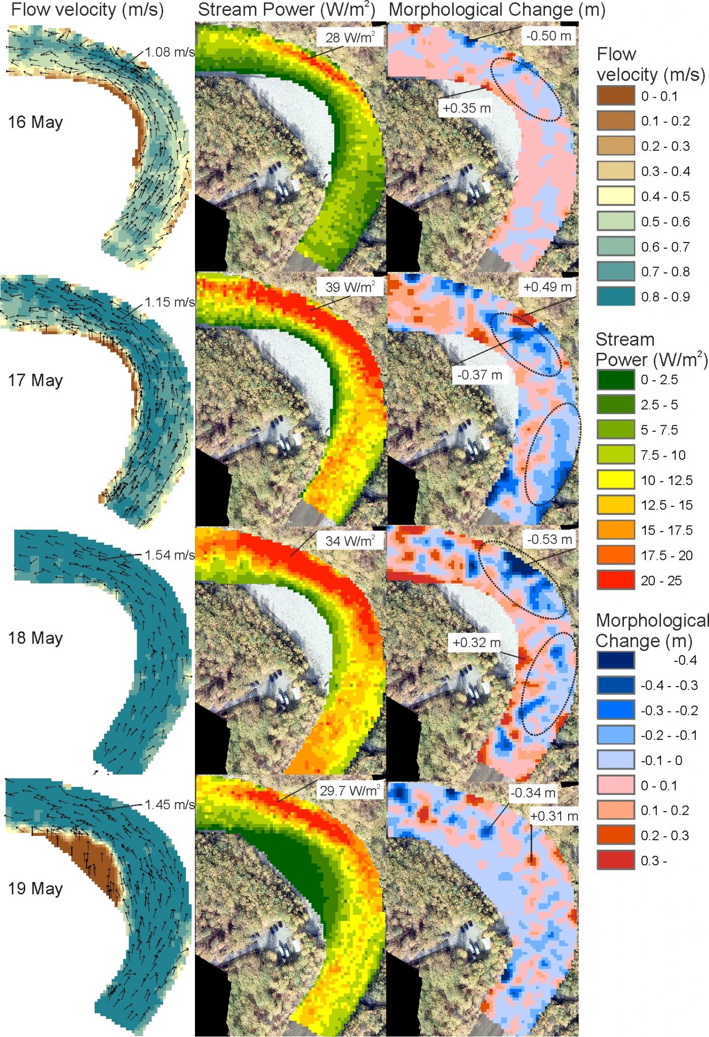
Figure 2. Flow and morphology measurements based on spatially and temporally dense ADCP survey. The spatial distribution of the horizontal near-bed flow velocity magnitude and direction (left), near-bed stream power (center) and the bed level change (right) from May 16th to May 19th. The highest measured flow velocities and stream powers are marked in the figure. Thematically interesting locations and magnitudes regarding the morphological changes are also marked. Note that different scales are used to visualize the stream power in parts 1 and 2, due to the notably lower stream power values during last four days (Kasvi et al., 2017, Water).
Flener, C., Wang, Y., Laamanen, L., Kasvi, E., Vesakoski, J., Alho, P. (2015). Empirical Modeling of Spatial 3D Flow Characteristics Using a Remote-Controlled ADCP System: Monitoring a Spring Flood. Water 7(1), pp.217-247. DOI.
Abstract:
The use of acoustic Doppler current profilers (ADCP) for measuring streamflow and discharge is becoming increasingly widespread. The spatial distribution of flow patterns is useful data in studying riverine habitats and geomorphology. Until now, most flow mapping has focused on measurements along a series of transects in a channel. Here, we set out to measure, model and analyze the 3D flow characteristics of a natural river over a continuous areal extent, quantifying flow velocity, 3D flow directions, volumes, water depth and their changes over time. We achieved multidimensional spatial flow measurements by deploying an ADCP on a remotely-controlled boat, combined with kinematic GNSS positioning and locally-monitored water level data. We processed this data into a 3D point cloud of accurately positioned individual 3D flow measurements that allows the visual analysis of flow velocities, directions and channel morphology in 3D space. We demonstrate how this allows monitoring changes of flow patterns with a time series of flow point clouds measured over the period of a spring flood in Finnish Lapland. Furthermore, interpolating the raw point cloud onto a 3D matrix allows us to quantify volumetric flow while reducing noise in the data. We can now quantify the volumes of water moving at certain velocities in a given reach and their location in 3D space, allowing, for instance, the monitoring of the high-velocity core and its changes over time.
Kasvi, E., Vaaja, M., Kaartinen, H., Kukko, A., Jaakkola, A., Flener, C., Hyyppä, H., Hyyppä, J. and Alho, P. (2015). Sub-bend scale flow–sediment interaction of meander bends — A combined approach of field observations, close-range remote sensing and computational modelling. Geomorphology, 238, pp. 119-134. DOI.
Abstract:
Various field-based studies of meander development have been realised, yet fluviomorphological processes and their spatial patterns over bends are not fully understood. In this paper, the processes of three natural meander bends during a flood event are dissected using a unique study approach, which combines traditional field surveying, close-range remote sensing, and computational modelling. The combined study approach improves the spatial and temporal resolutions of the data compared to traditional survey methods, although the bathymetric data collection needs improvement. The analyses indicate that the influence of a flood on the morphological changes of point bars depends on the stage of the bend’s development. The point bars may also experience lateral growth during low discharge. However, the point bar is too large a unit to find simplified relationships between the discharge and morphological changes. Instead, one should concentrate on different parts of the bend and the point bar. In general, the longer the inundation period of one part, the more probable that the area will experience net deposition. The magnitude of the sediment transport and the net morphological change are not interconnected: Areas of net erosion and deposition can experience either high or low sediment transport rates during a flood. The results are compared with earlier theories of meander development, which are also assessed.